


Jan 11, 2023
TECH & DESIGNAn agile approach to changing a company and society :yuriCargo for a safer and more secure mobility society (part two)
Scoring driving performance of drivers by an app to promote their greater safety awareness
The "yuriCargo" service developed by DENSO Corporation is designed to promote greater safety awareness among drivers. It can evaluate their driving performance and assign their scores by a smartphone app, and the driving data is used for projects in Kariya City and Obu City, Aichi Prefecture to inform drivers of accident blackspots on the roads where they tend to have close calls. DENSO’s yuriCargo is a major challenge toward greater driving safety in the connected-car era by using machine learning technology.
-
Cloud Services R&D Div.TAKESHI KURODA
Takeshi Kuroda joined DENSO as a new graduate in 2011. He was assigned to the Public Relations Div. and was involved in advertisement activities of aftermarket products and planning of the exhibitions such as Tokyo Motor show and others. In 2017, he was transferred to the Cloud Services R&D Div. by the in-house recruitment system. Currently, he is involved in sales activities and customer success management for yuriCargo customers.
-
Cloud Services R&D Div.WATARU UEHARA
Wataru Uehara joined DENSO as a new graduate in 2017 and was assigned to electric-vehicle motor design in the Electric Components Eng. Div. After participating in the company-wide recurrent education program in 2021, he was transferred to the Cloud Services R&D Div. As a data scientist, he is in charge of app and service data analysis, and creation and implementation of machine-learning models.
Contents of this article
Utilizing driving data of app users to visualize accident blackspots
— I understand that yuriCargo is designed to improve drivers’ safety awareness. How does it work?
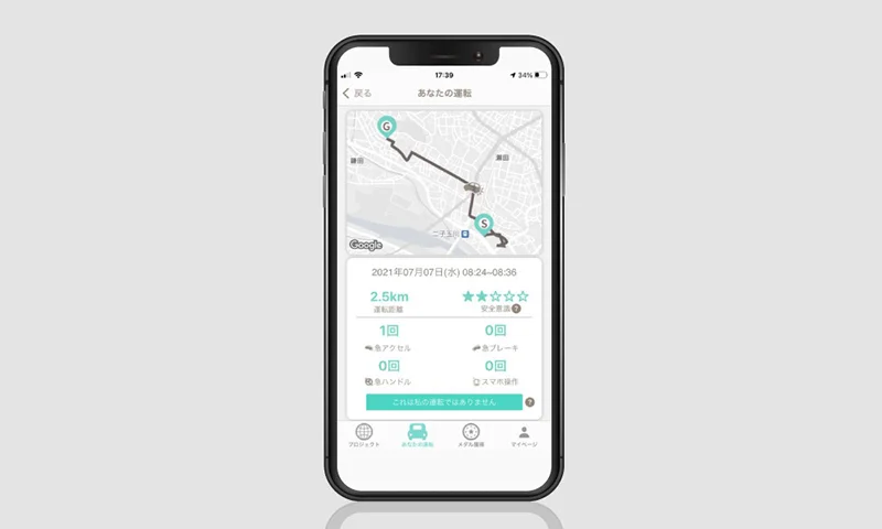
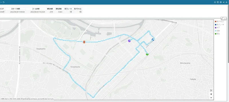
Takeshi Kuroda:Drivers just have to install the apps on their smartphones and drive their cars so that the apps automatically sense the movements of cars. Drivers do not have to do anything before driving as the apps use the smartphones’ GPS and accelerometer to monitor and record the actual driving route and driving behavior. After driving, the apps plot where the drivers hit the brakes and the accelerators on maps, and assign the scores of drivers’ safe driving awareness. This lets the drivers know when and where their scores are deducted and helps them realize their own driving habits that could be dangerous. By learning how safely they drive actually and reviewing their own driving, they can learn to drive more safely.
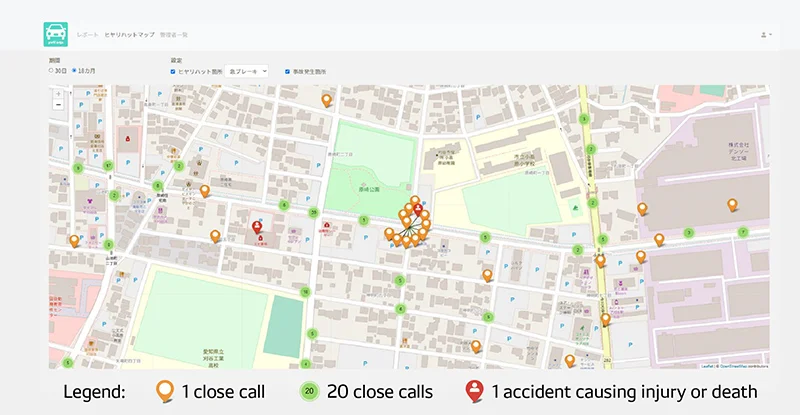
In addition, we aggregate their driving data in the cloud to visualize where drivers tend to have close calls, and work with local governments to use it for traffic safety measures.
— Can you give me some examples of how yuriCargo data is used in real-life projects?
Kuroda:In fiscal year 2021, we launched a project with Kariya City, Aichi Prefecture with the aim of reducing traffic accidents by raising safety awareness among participating drivers. We also launched a similar project with Obu City, Aichi Prefecture in fiscal year 2022 and have been using the data collected through these projects to identify potential risks and take measures.
— What kinds of people have joined these projects?
Kuroda:We have recruited participants widely from not only the residents in the cities but also whoever passes through the cities. The yuriCargo app is free, so participants only have to download and install it on their smartphone and then choose the Project where they want to participate. As of September 2022, there are about 2,700 participants in Kariya project.
— What were the results of the Kariya project over this past year?
Kuroda:As I mentioned, yuriCargo plots where many drivers hit the brakes and the accelerators on maps. By comparing this information with accident information from theNational Police Department, we have identified 28 spots where drivers have many close calls, and we called attention to the 28 spots through the app.
By including the specific place names in these calls, we can get drivers interested in the spots so that they take care of the spots in drivers' neighborhood.
Furthermore, we worked with E.design Insurance Co. Ltd to carry out onsite investigations at six of the spots, and then chose the Higashizakai-Maruyamacho intersection in Kariya for the case study. We took three types of traffic safety measures there: we made the stop signs clearer for the non-priority road in the intersection; we painted the caution of the high accident frequency intersection on the priority road; and we installed guard pipes on the sidewalks to protect pedestrians.
— How did the Obu project go?
Kuroda:The Obu city project started because the Obu city government empathize the concept of the project that the residents can contribute to the society by their driving data without any difficulty and that the city government can implement traffic safety measures based on the residents driving data. The aim of the project was identifying and analyzing potential risks on community roads, creating the traffic safety measures, and verifying the effectiveness of the measures by the data. The city government helped us convince residents’ associations and companies to take part in the project, and increasing numbers of companies are now lending us their support. As of September 2022 we have about 1,200 participants, and in October traffic safety measures were taken at three spots among those yuriCargo identified as spots where drivers had close calls.
*View the press release from Obu City (in Japanese).
— Have you been receiving feedback from yuriCargo project participants or local governments?
Kuroda:According to the user survey we carried out in September 2021, about 90 percent of participants said they had noticed they were more aware of safety while driving. In the survey some participants said they had consciously refrained from sudden driving operation, resulting in a safer driving style that puts other passengers in the vehicle at ease. In other words, using the app has made some participants change their driving style.
We have also found some problems in the feedbacks from city governments. Although many spots where drivers have close calls are concentrated along major roads with high traffic volumes, governments are interested in implementing traffic safety measures along narrower roads with high pedestrian traffic, and so they have been working to persuade residents in those areas to join the project.
For the Obu project, participating Komeda’s Coffee shops in the city have been offering special rewards to customers who drive safely. Drivers who use the yuriCargo app and achieve high safety awareness during driving are awarded in-app “medals,” and if they accumulate 10 or more medals by the end of every month, they can receive a Certificate of “Excellent Driver”.” They can then show this certificate at a Komeda’s Coffee shop to receive a free mini-size soft serve in return. In Kariya, some stores participate in a similar program, too, in order to increase the range of rewards for app users.
— That’s a good way to boost people’s motivation! How can drivers get the medals specifically?
Kuroda:They can get medals depending on the number of driving with the app, that of five-star driving, and also when they review their driving record and when their safety awareness is improved.
Currently, our analyses are based on driving data collected via the app, but in the future we hope to collect data in other ways in order to identify additional accident blackspots and rank them suitably. By providing visual information on vehicle speed, collecting feedback from local residents and other measures, we expect even more effective results from future analyses.
Using machine learning for automatic detection of transportation type
— What is the rough configuration of yuriCargo?
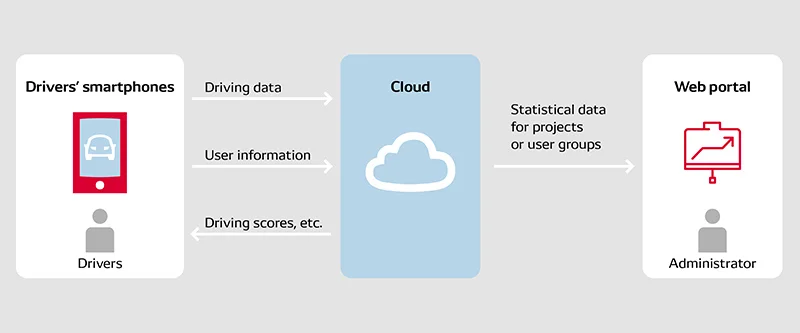
Kuroda:The user installs the app on their smartphone to enable driving data to be collected, and each time they finish driving, the data is uploaded to the cloud. It is then scored and processed before being stored in our database. Drivers can review their own driving data to learn about their driving habits and style, and local governments, companies and other organizations are supplied with statistical data based on user driving data in the form of close calls maps, project participation conditions and so forth.
—Because your goal of improving the safety awareness of drivers is abstract, I think it required many trials and errors to create a concrete system for your goal. What specifications and measures did you use?
Kuroda:We adopted an agile approach, talking with various companies and considering market needs while developing the system.
We originally assumed that we would be able to increase the safety awareness of drivers by providing feedback to them on their driving performance. Based on this approach, we developed our minimum viable product (hereafter referred to as MVP), and then asked DENSO employees to work with us to evaluate it.
Using the MVP, we were able to validate our original assumption to a degree. We then talked with a wide variety of companies in order to figure out what types of features users would expect, then developed a prototype system based on it. We got numerous companies to test this prototype in practice and give us feedback, and then made continual improvements as we went.
We repeated trials and errors not only to develop the software but also to create value propositions and business models of this project, such as that what types of date our users would like to use or how much they will pay for the system.
Even after releasing the yuriCargo app, we received feedback from users, companies, local governments and other parties, and used them not only to make improvements but also to add new functions as part of a continuing development cycle.
We didn’t strictly fix the final product specifications at the start; rather, we have been continually developing and tweaking them as we go.
— What type of functions have you added since the initial release?
Kuroda:Users had to touch a "start recording" button on the MVP of the app before they start driving, but they can’t help forget to start recording data in that way. If they remembered that they forgot to touch the button and used their smartphones while driving, it defeated the app’s original purpose of safe driving. Therefore, we updated the app so that it would automatically detect the start of driving and initiate data recording on its own.
Wataru Uehara:However, when we added this automatic recording feature, we encountered some new problems. The smartphone’s accelerometer was generally able to detect and identify the user’s transportation to a certain extent, but it could not do them with sufficient accuracy by itself. Therefore, we are now developing the identification processing of users’ transportation with machine learning on the cloud. One of our achievement is to eliminate trains as a possible transportation with a decision tree by machine learning.
A decision tree is a framework in which various criteria are established, and the data is compared with them one after another in order to categorize it. For our specific example, we used training data based on correct-answer information to build a learning model and thus were able to identify trains as a transportation. Compared with the deep learning approach, a decision tree has the advantage of clear decision-making criteria, but it also has the disadvantage of being difficult to improve prediction performance. Therefore, we decided to use ensemble learning, which uses multiple decision trees at the same time, to develop our model.
Specifically, we used gradient boosting, which is a unique type of ensemble learning in which model-correction priority is given to incorrect predictions seen in the learning process in order to promote more correct answers. Microsoft’s LightGBM is a popular framework [general-purpose software used to develop machine-learning models] in the machine learning field that makes use of gradient boosting, and we have used LightGBM in our development.
— How do you develop a transportation identification model?
Uehar:Broadly speaking, the data analysis process has six steps: data collection, data preprocessing, feature extraction, learning model creation, model performance evaluations and adjustments, and model implementation. The data preprocessing is especially challenging among them.
The yuriCargo app collects data using smartphone sensors, but when vehicles enter tunnels or underground sections of roads, GPS information from the smartphone becomes unreliable. As a result, data values of acceleration and speed are often abnormal. Thus, in the data preprocessing, we establish effective-range parameters for GPS-based data, or complement the abnormal data using the correct one that comes before or after the abnormal one.
In the feature extraction, we score the sharpness of curves in the movement route, and adopt them as the feature. As trains cannot turn sharp curves because of their structure unlike cars or pedestrians, we expect to greatly enhance identification precision for trains and other transportation with the feature in the future version of the app.
Creating a service for the connected-car era
— In addition to using machine learning for identifying the user’s transportation, have you used this approach to detect sudden braking and other such driving behavior?
Kuroda:With the current version of the app, a score is given only for each driving session as a whole, meaning the driver does not know exactly what to do to improve their driving. That’s why HMI R&I Dept of the Advanced Research and Innovation Center is researching on a new scoring system with machine learning that can calculate individual scores for each type of scenario, such as when making turns at an intersection and so forth.
In more concrete terms, the research entails creating base models of various driving scenarios based on driving performance by professional drivers, and then finding a way to assign user scores for each situation. We hope to advance collaborations with in-house engineers, such as R&D with data from yuriCargo.
— It seems that machine learning is fast becoming an important part of developing mobility services.
Uehar:That’s right. I had been involved in designing driving motors for electrification vehicles since I joined DENSO, but through the company-wide recurrent education program I became a software engineer.
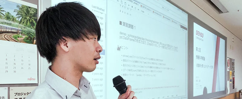
Recently, I was invited to give a special lecture on machine learning at Aichi Prefectural University, and I had students experience for themselves the process of predicting transportation using LightGBM together with actual yuriCargo data, which I have talked about in this interview. The lecture room was full during my lecture, and many students got interested in DENSO as a result. This reminded me of the immense interest in fields such as data science and AI nowadays.
— What are the future plans for yuriCargo?
Kuroda:In October 2022, we released "yuriCargo Insight", a new service that provides driving data for corporate customers. In recent years, some of our customer companies have been using mobility services such as rental cars and car sharing for business, and it’s generally difficult to install dashcams or similar in such services. These companies have asked DENSO to help them give safe driving instructions to their employees using yuriCargo, and thus we are pursuing development to meet their needs.
yuriCargo Insigh will enable quick identification of drivers with unsafe habits in order to have them attend driving classes, take e-learning courses and undergo other such training, which will help yuriCargo administrators at customer companies to prevent traffic accidents. Furthermore, they can compare their driving data before and after their training in order to visualize and understand changes in their driving awareness.
And as our customers request us to apply a similar approach to personal mobilities such as motorcycles and electric bicycles, and to Southeast Asian countries that suffer from frequent traffic accidents, we intend to challenge them in future.


By working with society such as our customers, universities and other organizations who would like to utilize yuriCargo data for various new applications, DENSO would like to create new values and services and have more drivers use them to jointly foster a safer society for all.
With an eye to the future, we should think what we can do for the society where connected cars are prevalent. Although DENSO currently collects data via users’ smartphones, we will upload them directly from vehicles to the cloud in the future. While continuing to explore the types of services that should be developed and provided throughout the world, DENSO is exploring potential applications of yuriCargo and related ecosystems.
For more information on yuriCargo advantages and application examples, visit:
REACTION

Changing your "Can'ts" into "Cans"
Where Knowledge and People Gather.

Leave a comment